Early indicators
Identify areas of variability, anomalies and potential ground concern early in project planning.
Space-enabled ground intelligence
GAIA is a space-enabled ground intelligence platform for construction and infrastructure. It combines Earth Observation with ground-sensing data to provide early indications of potential ground risks and support better-targeted site and geotechnical investigations.
EARLY INSIGHT. BETTER-INFORMED DECISIONS.
01 / THE PLATFORM
GAIA brings together Earth Observation and ground-sensing data to provide early site intelligence and help identify where further investigation may be needed.
Identify areas of variability, anomalies and potential ground concern early in project planning.
Combine wide-area Earth Observation with complementary site-level information.
Support engineers in prioritising areas for further site and geotechnical investigation.
Wide-area view of surface behaviour and change.
Site-level information on shallow subsurface conditions.
Data integration
and analysis
Clear, interpretable outputs to support planning and investigation.
02 / HOW IT WORKS
GAIA integrates satellite-derived ground behaviour with ground-sensing data to generate clear, site-specific indicators that support engineering decisions.
Explore the processEarth Observation data and complementary ground-sensing information.
Process and integrate datasets to identify patterns, anomalies and areas of interest.
Generate clear, engineering-relevant outputs.
Help prioritise further investigation and reduce uncertainty in early project stages.
03 / IMPACT
By providing early, evidence-based insights on ground conditions, GAIA helps reduce uncertainty, focus investigation efforts, and support more informed decision-making across the project lifecycle.
Discuss your projectBetter understanding of ground conditions earlier.
Focus resources where they are needed most.
Support safer, more resilient and cost-effective projects.
04 / DEVELOPMENT
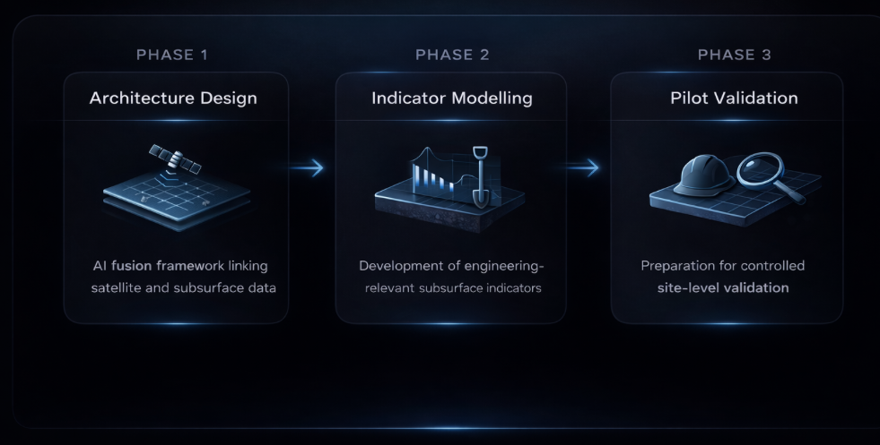
GAIA is advancing through structured development stages, from architecture design and indicator modelling towards pilot validation, to establish early-stage subsurface intelligence.
Development focuses on integrating data sources, modelling engineering-relevant indicators, and preparing for pilot validation in real project conditions.
GET IN TOUCH
Let’s explore how GAIA can support your next project.
Whether you’re planning a new infrastructure project or want to learn more about our approach, we’d be happy to start a conversation.